
 The buildings in the cleared area at the very bottom of the left map is the "Chinese Gardens".
The Canal leading to Gatun Locks is along the far left of the map. The water on the right side is Limon bay leading to the Third Cut.
The jungle area around Atlantic was a bit marshy and there was numerous ditches and streams all around. The point of land jutting out in the bay was a slowly rising rocky point.
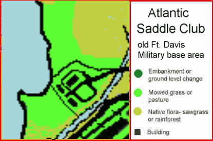
The large buildings around the highway dated to when the area was still part of the Old Ft. Davis military base. In the 70s they stil maintained and seemed to be used for storage of some sort. They had truck loading docks along the lenghts of the building. We used the docks for loading onto the open backed Howard trailer in the late 60s and early 70s, and for the semi van they used in the mid 70s. The image on the right shows how the area looked in the 40's in the hey day of the Military bases.